- Biblical Maps
- Home Page
- History of Israel Blog
- Ancient Mesopotamia
- Map of Palestine
- Abraham
- Ancient Israel
- 12 Tribes of Israel
- Jerusalem
- The Book of Isaiah
- Palestine
- The Habiru
- Contact Us
- Bible Study Forums
- Media Page
- Visitors Sitemap
- Privacy Policy
- The History of the Old Testament
- In the Days of Noah
- The City of Jericho
VISIT OUR FACEBOOK PAGE!
Old Testament Map & History
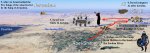
OLD TESTAMENT MAP OF KING DAVID was born in Bethlehem, in the south of Judah to Jesse, the son of Obed (Matthew 1:5). David was the youngest son of Jesse's and grew up tending the sheep. However, it was as a youth in the Valley of Elah where David showed what was to come. He fearlessly fought and killed the Philistine giant-champion Goliath, cutting off his head after sinking a stone from his sling in the giant's forehead.
King Saul took David in, only to turn against him out of jealousy and "an evil spirit". The old prophet Samuel had anointed Saul king years earlier, only to have him disobey the word of the Lord. Thus a new king was to be anointed, and God had chosen His servant David.

Samuel aided David in his flight from Saul. Earlier he had condemned
Saul per God's instruction. Saul had been rejected, and thus David's
rise to the throne was ordained by Yahweh making David the righteous and
chosen king. Indeed his kingdom would usher in the golden era of
Israelite/Jewish history. The kingdom established by he and his son
Solomon stretched from the Red Sea in the south to the Euphrates River
in the extreme north.

This Old Testament Map depicts the movements of David over the course of his life. The concentration of David's movements were centered in the central hill country within the tribal allotment of Judah. David was a southern boy, and intimately familiar with the desert wildernesses south of his boyhood Bethlehem. David was anointed king in Hebron, and oftentimes sought shelter in the area as King Saul pursued him with his army.
OLD TESTAMENT MAP PAGE CONTENTS
CLICK TO VIEW MORE OLD TESTAMENT BIBLE MAPS
Old Testament Timeline: Click on the link to view when the Old Testament narratives took place against the backdrop of world history.
Click on a link to visit that Old Testament Bible Map.
The Holy Land in the Modern Day
Old Testament Map of the Negev - Home of Abraham
Preceptaustin.org - An excellent site for Old Testament & Bible Study
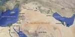
EDEN Scholars have sought for centuries to locate the Garden of Eden. The below map provides a look at what many feel may have represented the Bible's description in Genesis 2:10-14. Though this cannot be verified to any degree of certainty, it is interesting to note that geologists and scholars have concluded the Persian Gulf was at one time a dry river bed. The southern location is just one theory, however, concerning the location of the Garden of Eden.

Genesis 2 provides the first Old Testament map of the Bible. It is the first geographical reference in the history of man. The Bible is giving a description of where the Garden of Eden was. Thus, the first Old Testament map is that of Eden, and for centuries scholars have sought to draw that map.
THE PISHON & HAVILAH The Pishon is said to have flowed through the whole land of Havilah. Genesis 2:12
makes special mention of Havilah's gold being of the finest quality.
Interestingly, the river bed detected through new satellite imagery ran
through an ancient site known as Mahd adh Dhahab. This ancient mine was
one of antiquity's most well known and profitable gold mines.

King Solomon is believed to have obtained his gold from this mine. The massive amount of gold mined from this area is staggering. Could this area be the Biblical Havilah? Could the dried up river bed be the ancient remains of the River Pishon? The circumstantial evidence certainly matches the Biblical description of Eden given in the Bible.
THE HOLY LAND Many of the events on any Old Testament map took place in modern day Israel and Jordan. The ancient kings Og and Sihon , defeated by Moses, ruled kingdoms occupying much of modern day Jordan. The West Bank has been an area of dispute since Abraham. The history of Jerusalem is dominated by conflict.

The mighty Anakim occupied the land during the time of Abraham and the Conquest of Joshua. Hebron was their capital city, said in Joshua 14:15 to have been previously called Kiriath-Arba. Arba was the greatest among the Anakim, descendants of the Nephilim found in Genesis 6:4. It is no coincidence the violence in this region continues today, in these very same areas, and for many of the same reasons! The battle is one of a spiritual nature; as it was in the Old Testament, so it is today.

ENOCH The book of Enoch is one of the most fascinating pieces of literature ever written. It was written by Enoch the prophet , found in Genesis 5:21-24. Enoch was one of only two people in the Bible to not die. God took him up. I Enoch expands on the brief reference to the "sons of God" and "daughters of men" found in Genesis 6. Though not included in the modern era Bible, I Enoch was a part of the Greek Septuagint , and would have been read by Jesus and His disciples. Indeed, I Enoch is recognized as hugely influential in the writing of the New Testament. In fact, many scholars discredit Enoch as the writer because of the New Testament style and sounding of the book. In his book, Enoch describes the fallen Watchers, the "sons of God" in the Bible. He says they touched down on the peak of Mt. Herman, and migrated out from there. The kingdom of Og was located in Bashan, just south of Mt. Herman. Og was of the Rephaim, identified with the Anakim in Deuteronomy 2:11, and a people of great stature. The Temple at Baalbek has puzzled scholars since its discovery. It is one of the world's oldest sites, and has massive stones weighing 1200 tons! Could this be an ancient temple of the fallen Watchers? Enoch was ordered by God to confront these Watchers. A comparison of Enoch's geography correlates with an Old Testament map of the region mentioned. By the waters of Dan, Enoch received a vision from God. He then ventured to confront the congregation of Watchers to give them God's verdict at Mt. Hermon.
TABLE OF NATIONS An Old Testament map of Genesis 9, commonly referred to as The Table of Nations. The events in Genesis 6 and I Enoch triggered God's judgment of the flood. After the flood, it was up to Noah and his three sons to re-populate the earth. The above map shows their migration; Ham's descendants are seen in green. Shem's clans are in red. Japheth's kin are seen in black. Notice the tendency to stay relatively close to immediate family. The Old Testament map below shows some other clans, those that migrated further away.


THE SONS OF NOAH & THEIR DESCENDANTS SPREAD UPON THE EARTH FROM ARARAT. THESE MAPS DEMONSTRATE THEIR MIGRATION & SETTLEMENT. SHEM AND HAM TENDED TO DWELL AMONGST EACH OTHER MORESO THAN JAPHETH & HAM.
PALESTINE Palestine was occupied long before the Israelites arrived in the land, and even long before the patriarch
Abraham
arrived. An Old Testament map of Palestine, also called the land of
Canaan, shows a diverse landscape. Every known geographical region
exists in Canaan. From the coast of the Mediterranean, to the desert
regions of Judah and the Negev; from the lowlands of the Shephelah, to
the mountains of the Central Highlands, Palestine covers the spectrum of
geography.

Valleys cut through the land in various places. The Jezreel Valley has seen bloodshed since the beginning of time. It's strategic importance lay in the fact it led to the heartland of Palestine if approaching from the north. It is in the Jezreel Valley the Battle of Armageddon will one day take place. Megiddo, an ancient city of importance, commands the Jezreel. The Jordan Valley slices through Canaan on a north-south axis, providing the eastern border of the Promised Land.

The Philistines occupied the plain of Philisitia. The five cities under Philistine control made up what was known as the Philistine Pentapolis. These cities were Ekron, Gath, Gaza, Ashkelon, and Ashdod. These Philistine cities dominated the Coastal Plain, forcing the Israelites into the Western Mountains.
An Old Testament map may list the Western Mountains as the Central Highlands. The Hill Country of Ephraim was also located in this region. Jerusalem and Shechem dominated the Western Mountains. Shechem became the capital of the Northern Kingdom, while Jerusalem became the capital of the Southern Kingdom of Judah. The Central Ridge Route ran along the top of the plateau, and was a vital road in antiquity, as it remains today. Abraham spent much of his time in the southern Negev country. Beersheba was a major city of the Negev, and was home to Abraham for a time. Much of the Abraham narrative, and that of Isaac as well, takes place between Beersheba in the Negev, and Mamre, near Hebron, both located south of Jerusalem.

ANCIENT PALESTINE Any Old Testament map will reveal the land of Canaan was a well connected land even in ancient times. Many routes of ancient importance criss-crossed the land. Running on a north-south route, three vital ancient highways dissected Palestine. Starting in the west, along the Mediterranean Coast was the International Coastal Highway. This ancient highway carried trade goods which were vital to the economy of the Ancient Near East. Many different armies traversed this route en route to battle, or perhaps returning from defeat. The ancient city of Megiddo sat astride the Aruna Pass; where the I.C.H. enters the ever strategic Jezreel Valley. Megiddo, perhaps more so than any other city of the time, saw blood shed and war regularly in attempts to control this vital route.
|
The writer of Revelation foresaw the last battle, the Battle of Armageddon, as being fought in this area. Along the Western Mountains ran the Central Ridge Route. This route pierced the heart of Jerusalem, and connected the ancient city to Shechem, in Samaria. The two cities were Canaanite rivals for control of this ancient route before Abraham arrived. |
East of the Jordan, in what would become known as the Transjordan region, The Kings Highway ran from north to south. This route is mentioned in Numbers 21:22 by name. This route ran from Ezion-geber, at the top of the Gulf of Aqaba, northward to Damascus. Caravans ran this route carrying spices and perfumes, along with other products from the Arabian Peninsula.
ABRAHAM was called from the land of Ur, in southern Mesopotamia. The Old Testament map of Israel began with Abraham's journey into Canaan. It is believed by some scholars Ur was suffering a depression of sorts near the end of the third millennium B.C., which would have explained God's call to leave Ur. Abraham and his father, Terah, along with his nephew Lot, and their wives, left their home and journeyed to Haran. It is widely held they made this trip around 2000 B.C., though the exact dates vary from scholar to scholar. Haran is likely named after Abraham's brother, who had died unexpectedly in Ur, leaving his only son Lot behind for Abraham to raise. The most likely route they took from Ur led through the ancient city of Mari.

The Akkadians founded an empire in Mari. An alternate possibility would have taken Abraham and Terah up the Tigris River to Nineveh. From Nineveh, another city of Old Testament significance, the party would have traveled west to Haran. This Old Testament map of Abraham's journey depicts a long and arduous journey. After the crew arrived in Haran, the Bible indicates they stopped for an untold amount of time. Genesis 12 opens up with God's call for Abraham to leave his father's household and Haran, and to journey "To the land which I will show you".

ARAM-NAHARAIM This Old Testament map of the Land of the Patriarchs shows the importance this area played in shaping the early narratives in Genesis. It is from this region Abraham's family lived. Scholars have noted at least two cities, Haran and Nahor, which bear names of Abraham's kin. Abraham sent his servant to this region to fetch a wife for his son, Isaac. Purity was essential to the ancient Hebrews, later to be Israelites. Intermarriage was forbidden, and oftentimes led to conflict and unrest. It was to this area Jacob, Isaac's youngest son, fled in haste to escape the wrath of Esau, the oldest of the twin boys. Jacob spent twenty years in the region, before returning to Canaan with two wives from among his kin. The Old Testament map is crisscrossed with journeys by different patriarchs to the same areas.

ABRAHAM entered Canaan by way of the Jabbok River. He crossed the Jordan where the two rivers meet. This Old Testament map shows how Abraham and party followed the Wadi Farah into the Central Highlands. Genesis 12:6 records Abraham stopping near Shechem at "the oak of Moreh". Shechem, thus, became a significant part of the early history of Israel. Two of Jacob's sons would put to death the residents of Shechem in retaliation for the rape of their sister. After stopping at the oak of Moreh, the Lord appeared to Abraham in an act of reassurance. Abraham built an altar to commemorate the occasion.

EARLY CANAAN was a diverse and busy land. Any Old Testament map
attests to the number of cities, towns, and villages which sprang up
near ancient trade routes, intersections, water sources, hill tops, and
valleys. As Abraham entered Canaan, the Central Ridge Route would have
led southward to Jerusalem. Bethel, Ai, and Gibbeon sat along this
route. Jericho lay 18 miles to the east of Jerusalem. Continuing along
the same route to the south of Jerusalem sat Hebron, and Beersheba in
the Negev lay to the southwest of Hebron. This Old Testament map makes
evident the choice of Joshua to invade Canaan through
Jericho
. Before crossing the Jordan, Joshua and the Israelites encamped at
Abel-shittim. Jericho was a strategic city, as the Israelites would have
been able to access the Central Highlands by way of three routes, if
the city could be taken. Upon seizing Jericho, Joshua chose the route
leading northwest, to Ai and Bethel. They were defeated initially at Ai;
a consequence of the sin of Achan. However, the second attempt
delivered a fatal blow. This began the southern campaign of the
Conquest.

CHEDERLAOMER and his alliance of kings from Mesopotamia subjugated the kings of
Sodom and Gomorrah
. The story, found in Genesis 14, indirectly involves Abraham
when his nephew Lot is taken captive by the invading army. The kings of
Sodom and Gomorrah, along with an alliance of the kings of Admah,
Zeboiim, and Zoar, refused to pay tribute in the thirteenth year of
their subjugation. Their refusal was met by a brutal offensive by
Chederlaomer. He ravaged the neighboring countries on his way southward
to the cities of the Plains. This Old Testament map depicts his likely
route of invasion. Chederlaomer utterly destroyed the alliance of rebel
kings, taking many of the inhabitants captive, destined to likely become
slaves, or worse. Abraham was told of Lot's fate by one who had managed
to escape. Along with his Amorite friends, among others, Abraham
tracked down the army and over ran them near Dan. He rescued Lot, and
scattered the invading force. This led to the interesting encounter with
the mysterious Melchizedek.
OLD TESTAMENT MAP

THE NEGEV was home to Abraham and Isaac throughout their sojourn in Canaan. This Old Testament map shows the land Abraham and Isaac journeyed in. The primary city of the Negev, or Negeb, is Beersheba. Remains of the store facility and gate complex at the ancient site date back to the time around Abraham, from the Iron II period dating 900-600 B.C. This region only receives ten to twelve inches of water a year, thus water is a scarce resource in this region. Because of this fact, numerous wells have been dug along the major wadis. Abraham is recorded in Genesis as digging many wells throughout his travels. The Amalekites, and other nomadic tribes, roamed the Negev as well. I Samuel 30 depicts David and his men defeating the Amalekites in Ziklag, a city of the Negev between Gerar and Beersheba. Scripture records the Amalekites had raided Ziklag, overthrown the city, and burnt it to the ground.
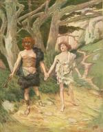
JACOB & ESAU grew up in the Negev, in and around Beersheba and Hebron. The Central Ridge Route connected the two cities. Esau was an outdoorsman, and sought the wild game found nearby. Jacob, however, preferred to stay with the tents.

This worked to his advantage in Genesis 25:29. Esau had been in the fields all day hunting, and came in famished. He begged Jacob for some of the food he had just cooked. Jacob replied he would only feed Esau in exchange for his birthright. Esau flippantly obliged, and ate his fill. Esau became the favorite of Isaac, while Jacob was his mother's favorite. Eventually, Jacob and his mother would conspire together to deceive Isaac into blessing Jacob rather than Esau. This would prove too much for Esau, and in Genesis 27:41 he was overheard uttering threats against his brother's life. Rebekah, fearing for Jacob's life, urged Isaac to send him away to obtain a wife from their kin in Aram-Naharaim.

JACOB took flight on a route which must have been very familiar to the Patriarchs; the route to Aram-Naharaim, some 500 plus miles to the Northeast of Canaan. This route is engraved on the Old Testament map of the early Patriarch's. Jacob took out in haste, fleeing the wrath of Esau. It is interesting to keep in mind Scripture's description of Jacob as a quiet man, a man that chose to stay among the tents. He was not an out doors type. This journey, taken in haste, would have tested him in ways he had never been tested before. This Old Testament map of Jacob's flight illuminates the route he would have most likely taken. As stated above, this route was well known by Abraham, Isaac, and now Jacob. Jacob would not return this way for another twenty years.
Continue to view more Old Testament Bible maps.
Map Ideas? Questions and/or Comments?
Are you a fan of Old Testament geography and maps? Do you have map ideas? Submit them here!
What Other Visitors Have Said
Click below to see contributions from other visitors to this page...
Map of Palestine 
The Land of the Canaanites was never named Palestine until a Roman emperor asked a local resident who the most feared enemies of Israel were, the resident …
Possible Route of Mary & Joseph
I would be interested in a map that shows all the existing roads, and the possible routes Mary and Joseph took from Nazereth to Bethlehem. I would be very …
Mountain of the Lord Garden of God
I am a 61 yr. old Baptist Missionary to tribal people of Southern Zambia. Maps and places are a passion with me. I am convinced the Mountain area of …
Family Blessings
Genesis talks about the beginning of the world, how Adam and Eve started as the first couple that God created and began their own family. The history of …
The Eden and the Garden of the Lord 
Having read scriptures,including Jewish jubilees, the LORD Gd gave me this revelation. According to the account of Lot in Genesis 13:10, the garden of …
Zoar Not rated yet
I find the history of Zoar, but I am not finding it on maps. Why?
Jerusalem or Bethlehem? Not rated yet
I understand that when Jesus returns He will do away with the old earth and heavens and replace them with new. However, during end times, will it be safer …
Judges 4 Deborah & Barak Not rated yet
I am studying the story of Deborah and Barak in Judges 4 and would like to see a map of where Deborah was, and where Barak was, and where the river …
Map of the Sons and Grandsons of Noah Not rated yet
I am doing a study of the prophesies of Daniel, Ezekiel and Revelation. It would help to have a map that showed the peoples before and up to Abraham.
Valley of Beracha Not rated yet
Such an amazing testament of giving God the Glory and allowing and obeying God. Would love to see where that was, and still is.
Recent Articles
-
The History of Ancient Israel
Dec 25, 23 02:16 PM
 An easy to read history of ancient Israel from Old Testament times to today.
 -
The Ancient City of Jericho
Dec 18, 23 11:21 PM
 The city of Jericho is one of the most ancient cities on earth. The city played a crucial role in a number of Bible stories.
 -
Story of Cain and Abel
Dec 17, 23 01:20 PM
 The story of Cain and Abel is a tragic story of jealousy, rage and fratricide. It is the first murder in recorded history.
SAMUEL the SEER
Now Available in Print & eBook on Amazon!!
POPULAR TOPICS
Learn more about these popular topics below. The Bible is full of fascinating stories, characters and mysteries!
BIBLE MAPS
Explore the land of the Old Testament! View these maps of the Bible.